Research background
My research fields are Human Computer Interaction, Usability, Information Design, Videogame design. I’m interested in researching the tools and the ways we use to communicate with computers and digital devices considering emerging technologies and alternative ways of relating with computers (touch screens, physical interfaces, etc.). The problems I am concentrating on are the used metaphors (office/desktop metaphor), hardware interfaces (mouse, keyboard), learning curves, usability, complexity Vs simplicity.
Starting from the assumption that the desktop metaphor and the Graphical User Interface (GUI) in use nowadays are not adequate for our needs, I’m investigating possible alternatives to the current paradigm.
‘Modern computing is based on an analogy between computers and file cabinets that is fundamentally wrong and affects nearly every move we make. (We store "files" on disks, write "records," organize files into "folders" — file-cabinet language.) Computers are fundamentally unlike file cabinets because they can take action. Metaphors have a profound effect on computing: the file-cabinet metaphor traps us in a "passive" instead of "active" view of information management that is fundamentally wrong for computers.’ David Gelernter, The Second Coming, http://www.edge.org/3rd_culture/gelernter/gelernter_p1.html
I started from the idea of approaching computer interfaces using a different metaphor than the classical office and desktop ones. I explored the use of maps (information design). Maps have always been used to help explore unknown places. Maps are also used in others field than geography, e.g. marketing (perceptual mapping), social and economic studies, psychology, etc. Maps use heavily visual information, colors, shapes, labels to help people orientate within very rich information spaces.
‘When I look at a map to find a particular detail I do not start at one corner and laboriously work my way across it regarding every single street name. My first action is to look at the whole in order to get an overview of the area. Next I identify the part I am interested in, and only then do I narrow my perspective (zoom in) and start looking at the detail in that area. When I make that overview I am not looking at detail. I am interested ony in an handful of large features that help me to put the rest in context. I look at the rivers, canals, the green splotches of parkland and at the main roads and railways. Usually maps are designed so that these key orientation features are more visible and more noticeable; they are in brighter, richer colours or drawn thicker and larger than other features.’ Lon Barfield, The User Interface: Concepts & Design p.64
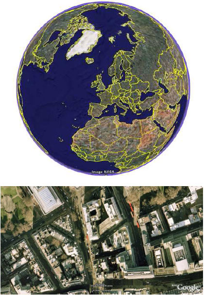
Todays technologies allow us to have more and more
detailed maps, and offer us new powerful ways of exploring
them.
For example Google Maps and Google Earth allows passing
easily from a worldwide view to a very detailed street view,
and explore different aspects of the Planet (streets maps,
satellite pictures, terrains).
The map concept is more widespread than office concepts such as desktop, folders, file cabinet. Maps use a language developed through centuries, their language can be successfully employed in interface design and the information stored on the virtual computer space can be explored using a map metaphor.
‘it seems that decoding a map, be it spatial or thematic,
results quite natural for most of the human beings, requiring
just very little training.’
Juan C. Dürsteler, The Landscape Metaphor
http://www.infovis.net/printMag.php?num=168&lang=2
‘What we are truly better at is remembering landmarks and
positional cues’
Jef Raskin, The Human Interface p.152